News
Upcoming Events
Subscribe our events list with your calendar app!
- Kraichtal-Gochsheim / TV 07 Gochsheim e.V. / Baden-Württemberg
Trails: 5/10 km - Start: 07:00 - 13:00 hours - Address: Clubhaus SV Gochsheim, Immenstraße 26, 76703 Kraichtal-Gochsheim - Club Homepage - GPS-coordinates: 49.100301,8.737252 - Google-driving directions - Public Transport Stop: Deutsche Bahn Gochsheim(Baden) (20 minutes footway)
- Ruppertshofen / Rottal-Wanderfreunde Ruppertshofen e.V. / Baden-Württemberg
Trails: 5/10/20 km - Start: 07:00 - 13:00 hours - Address: Kultur- und Sportzentrum Jägerfeld, Erlenstraße 13, 73577 Ruppertshofen - GPS-coordinates: 48.886442,9.812321 - Google-driving directions
- Vogt / Wanderfreunde Vogt e.V. / Baden-Württemberg
Trails: 5/10 km - Start: 07:00 - 14:00 hours - End: 16:00 hours - Address: Sirgensteinhalle, Schützenweg 6, 88267 Vogt - GPS-coordinates: 47.776135,9.769281 - Google-driving directions - Public Transport Stop: Deutsche Bahn Ravensburg (Shuttle service only if reservated) - Download Flyer
- Offenburg-Elgersweier / Wanderfreunde Elgersweier e.V. / Baden-Württemberg - Guided Volksmarch
Trails: 5/10 km - Start: 10:00 hours - Address: Festhalle Elgersweier, Hebelstraße 12, 77656 Offenburg-Elgersweier - GPS-coordinates: 48.438657,7.946139 - Google-driving directions
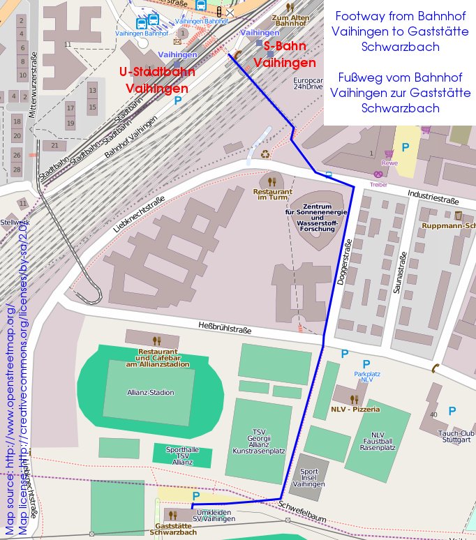
- Club Meeting - Stuttgart-Vaihingen
Start: 19:00 hours - End: 22:00 hours - Address: Gaststätte Schwarzbach, Dürrlewangstraße 70, 70565 Stuttgart - Club Homepage - GPS-coordinates: 48.721822,9.111981 - Google-driving directions - Public Transport Stop: Deutsche Bahn Stuttgart-Vaihingen (6 minutes footway directions) - Guests always welcome! - Dinner available from 1800.
- Rheinau-Diersheim / Wanderfreunde Unteres Hanauerland e.V. Lichtenau-Muckenschopf / Baden-Württemberg - Guided Volksmarch
Trails: 12 km - Start: 10:00 hours - Address: Ortsverwaltung Diersheim, Hanauer Straße 23, 77866 Rheinau-Diersheim - GPS-coordinates: 48.648072,7.891875 - Google-driving directions
- Titisee-Neustadt / Wanderfreunde Titisee-Neustadt e.V. / Baden-Württemberg - Guided Volksmarch
Trails: 5/10/15 km - Start: 10:00 hours - Address: Imbiss und Metzgerei Adler, Freiburger Straße 3b, 79822 Titisee-Neustadt - Club Homepage - GPS-coordinates: 47.923402,8.191408 - Google-driving directions - Public Transport Stop: Deutsche Bahn Neustadt Posthäusle, Titisee-Neustadt (1 minutes footway) - Download Flyer
- Schorndorf-Weiler / Berg- und Wanderfreunde Schorndorf und Umgebung e.V. / Baden-Württemberg
Trails: 5/10/20 km - Start: 07:00 - 13:00 hours - Address: Vereinsheim der Berg- und Wanderfreunde Schorndorf-Weiler, Lortzingstraße 42, 73614 Schorndorf-Weiler - GPS-coordinates: 48.795897,9.511367 - Google-driving directions - Public Transport Stop: Deutsche Bahn Weiler(Rems) (15 minutes footway)
- Vogtsburg-Oberbergen / Wanderfreunde Oberrotweil e.V. / Baden-Württemberg
Trails: 6/12/21 km - Start: 08:00 - 13:00 hours - End: 17:00 hours - Address: Winzergenossenschaft Oberbergen, Badbergstraße 2, 79235 Vogtsburg-Oberbergen - GPS-coordinates: 48.094330,7.651653 - Google-driving directions - Download Flyer
- Bad Rappenau-Grombach / Kraichgau-Wanderer Grombach e.V. / Baden-Württemberg - Guided Volksmarch
Trails: 20 km - Start: 09:00 hours - End: 13:30 hours - Address: Züchterheim, Mühlstraße 12, 74906 Bad Rappenau-Grombach - GPS-coordinates: 49.224191,8.984946 - Google-driving directions - Public Transport Stop: Deutsche Bahn Grombach (10 minutes footway) - Download Flyer
- Bad Rappenau-Grombach / Kraichgau-Wanderer Grombach e.V. / Baden-Württemberg - Guided Volksmarch
Trails: 10 km - Start: 09:30 hours - End: 12:30 hours - Address: Züchterheim, Mühlstraße 12, 74906 Bad Rappenau-Grombach - GPS-coordinates: 49.224191,8.984946 - Google-driving directions - Public Transport Stop: Deutsche Bahn Grombach (10 minutes footway) - Download Flyer
- Bad Rappenau-Grombach / Kraichgau-Wanderer Grombach e.V. / Baden-Württemberg - Guided Volksmarch
Trails: 6 km - Start: 10:00 hours - End: 11:30 hours - Address: Züchterheim, Mühlstraße 12, 74906 Bad Rappenau-Grombach - GPS-coordinates: 49.224191,8.984946 - Google-driving directions - Public Transport Stop: Deutsche Bahn Grombach (10 minutes footway) - Download Flyer
- Freiamt-Mußbach / Motorsport Racing-Team Freiamt e.V. / Baden-Württemberg - Guided Volksmarch
Trails: 8 km - Start: 10:00 hours - Address: Clubhaus Motorsport Racing-Team, Am Bus 57, 79348 Freiamt-Mußbach - Club Homepage - GPS-coordinates: 48.173423,7.893592 - Google-driving directions - Download Flyer
- Council Meeting - Stuttgart-Vaihingen
Start: 19:00 hours - End: 22:00 hours - Address: Restaurant Römerhof, Robert-Leicht-Straße 93, 70563 Stuttgart-Vaihingen - Club Homepage - GPS-coordinates: 48.738684,9.106727 - Google-driving directions - Public Transport Stop: Deutsche Bahn Universität, Stuttgart (10 minutes footway) - All members always welcome! - Dinner available from 1800.
More IVV walks...
- Kraichtal-Gochsheim / TV 07 Gochsheim e.V. / Baden-Württemberg
Trails: 5/10 km - Start: 07:00 - 13:00 hours - Address: Clubhaus SV Gochsheim, Immenstraße 26, 76703 Kraichtal-Gochsheim - Club Homepage - GPS-coordinates: 49.100301,8.737252 - Google-driving directions - Public Transport Stop: Deutsche Bahn Gochsheim(Baden) (20 minutes footway)
- Ruppertshofen / Rottal-Wanderfreunde Ruppertshofen e.V. / Baden-Württemberg
Trails: 5/10/20 km - Start: 07:00 - 13:00 hours - Address: Kultur- und Sportzentrum Jägerfeld, Erlenstraße 13, 73577 Ruppertshofen - GPS-coordinates: 48.886442,9.812321 - Google-driving directions
- Vogt / Wanderfreunde Vogt e.V. / Baden-Württemberg
Trails: 5/10 km - Start: 07:00 - 14:00 hours - End: 16:00 hours - Address: Sirgensteinhalle, Schützenweg 6, 88267 Vogt - GPS-coordinates: 47.776135,9.769281 - Google-driving directions - Public Transport Stop: Deutsche Bahn Ravensburg (Shuttle service only if reservated) - Download Flyer
- Offenburg-Elgersweier / Wanderfreunde Elgersweier e.V. / Baden-Württemberg - Guided Volksmarch
Trails: 5/10 km - Start: 10:00 hours - Address: Festhalle Elgersweier, Hebelstraße 12, 77656 Offenburg-Elgersweier - GPS-coordinates: 48.438657,7.946139 - Google-driving directions
- Club Meeting - Stuttgart-Vaihingen
Start: 19:00 hours - End: 22:00 hours - Address: Gaststätte Schwarzbach, Dürrlewangstraße 70, 70565 Stuttgart - Club Homepage - GPS-coordinates: 48.721822,9.111981 - Google-driving directions - Public Transport Stop: Deutsche Bahn Stuttgart-Vaihingen (6 minutes footway directions) - Guests always welcome! - Dinner available from 1800.
- Rheinau-Diersheim / Wanderfreunde Unteres Hanauerland e.V. Lichtenau-Muckenschopf / Baden-Württemberg - Guided Volksmarch
Trails: 12 km - Start: 10:00 hours - Address: Ortsverwaltung Diersheim, Hanauer Straße 23, 77866 Rheinau-Diersheim - GPS-coordinates: 48.648072,7.891875 - Google-driving directions
- Titisee-Neustadt / Wanderfreunde Titisee-Neustadt e.V. / Baden-Württemberg - Guided Volksmarch
Trails: 5/10/15 km - Start: 10:00 hours - Address: Imbiss und Metzgerei Adler, Freiburger Straße 3b, 79822 Titisee-Neustadt - Club Homepage - GPS-coordinates: 47.923402,8.191408 - Google-driving directions - Public Transport Stop: Deutsche Bahn Neustadt Posthäusle, Titisee-Neustadt (1 minutes footway) - Download Flyer
- Schorndorf-Weiler / Berg- und Wanderfreunde Schorndorf und Umgebung e.V. / Baden-Württemberg
Trails: 5/10/20 km - Start: 07:00 - 13:00 hours - Address: Vereinsheim der Berg- und Wanderfreunde Schorndorf-Weiler, Lortzingstraße 42, 73614 Schorndorf-Weiler - GPS-coordinates: 48.795897,9.511367 - Google-driving directions - Public Transport Stop: Deutsche Bahn Weiler(Rems) (15 minutes footway)
- Schorndorf-Weiler / Berg- und Wanderfreunde Schorndorf und Umgebung e.V. / Baden-Württemberg
Trails: 5/10/20 km - Start: 07:00 - 13:00 hours - Address: Vereinsheim der Berg- und Wanderfreunde Schorndorf-Weiler, Lortzingstraße 42, 73614 Schorndorf-Weiler - GPS-coordinates: 48.795897,9.511367 - Google-driving directions - Public Transport Stop: Deutsche Bahn Weiler(Rems) (15 minutes footway)
- Vogtsburg-Oberbergen / Wanderfreunde Oberrotweil e.V. / Baden-Württemberg
Trails: 6/12/21 km - Start: 08:00 - 13:00 hours - End: 17:00 hours - Address: Winzergenossenschaft Oberbergen, Badbergstraße 2, 79235 Vogtsburg-Oberbergen - GPS-coordinates: 48.094330,7.651653 - Google-driving directions - Download Flyer
- Bad Rappenau-Grombach / Kraichgau-Wanderer Grombach e.V. / Baden-Württemberg - Guided Volksmarch
Trails: 20 km - Start: 09:00 hours - End: 13:30 hours - Address: Züchterheim, Mühlstraße 12, 74906 Bad Rappenau-Grombach - GPS-coordinates: 49.224191,8.984946 - Google-driving directions - Public Transport Stop: Deutsche Bahn Grombach (10 minutes footway) - Download Flyer
- Bad Rappenau-Grombach / Kraichgau-Wanderer Grombach e.V. / Baden-Württemberg - Guided Volksmarch
Trails: 10 km - Start: 09:30 hours - End: 12:30 hours - Address: Züchterheim, Mühlstraße 12, 74906 Bad Rappenau-Grombach - GPS-coordinates: 49.224191,8.984946 - Google-driving directions - Public Transport Stop: Deutsche Bahn Grombach (10 minutes footway) - Download Flyer
- Bad Rappenau-Grombach / Kraichgau-Wanderer Grombach e.V. / Baden-Württemberg - Guided Volksmarch
Trails: 6 km - Start: 10:00 hours - End: 11:30 hours - Address: Züchterheim, Mühlstraße 12, 74906 Bad Rappenau-Grombach - GPS-coordinates: 49.224191,8.984946 - Google-driving directions - Public Transport Stop: Deutsche Bahn Grombach (10 minutes footway) - Download Flyer
- Freiamt-Mußbach / Motorsport Racing-Team Freiamt e.V. / Baden-Württemberg - Guided Volksmarch
Trails: 8 km - Start: 10:00 hours - Address: Clubhaus Motorsport Racing-Team, Am Bus 57, 79348 Freiamt-Mußbach - Club Homepage - GPS-coordinates: 48.173423,7.893592 - Google-driving directions - Download Flyer
- Council Meeting - Stuttgart-Vaihingen
Start: 19:00 hours - End: 22:00 hours - Address: Restaurant Römerhof, Robert-Leicht-Straße 93, 70563 Stuttgart-Vaihingen - Club Homepage - GPS-coordinates: 48.738684,9.106727 - Google-driving directions - Public Transport Stop: Deutsche Bahn Universität, Stuttgart (10 minutes footway) - All members always welcome! - Dinner available from 1800.
More IVV walks...